
Gold Lane, Biddenham
Between January 2021 and January 2022, Albion Archaeology undertook archaeological open-area excavation totalling c.7ha, in advance of residential development at Gold Lane, on the north-west edge of Biddenham, Bedfordshire. The works were commissioned by RPS Consulting on behalf of Dandara. News coverage of the project has included BBC News and other news websites worldwide.
Fieldwork revealed rich archaeological remains dating from the Neolithic to the late Anglo-Saxon periods. Bedford Borough Council granted planning permission for a residential development on the north-west outskirts of Biddenham. A condition of the consent required a programme of archaeological work to ensure that features of archaeological interest were properly examined and recorded prior to development. Previous archaeological work within the site had comprised geophysical survey and trial trenching.

Excavations underway, modern Bromham visible in the background.
NEOLITHIC/BRONZE AGE
The earliest remains comprised a Neolithic or early Bronze Age circular monument, which would have formed part of a wider landscape of similar monuments known to have existed locally within a loop of the river Great Ouse. The monument, which may have been constructed as much as 6000 years ago (4000 BC), is thought to have provided a focus for ceremonial and ritual activities. It is described in more detail below.
During the middle to late Bronze age (1500–800 BC) the land was divided into large fields bounded by ditches. These ditches appeared to respect the location of the earlier monument, suggesting it still existed as a feature of the landscape at this time. One of the ditches blocked the entrance of the monument, however, perhaps indicating that it was no longer utilised for its original function. In the late Bronze Age or early Iron Age (800–450 BC), two smaller ditched enclosures – one rectangular and one D-shaped – were established. These likely represent the locations of small-scale or seasonal settlement, with some evidence for small structures or buildings within.

The circular monument, partially excavated.
A circular monument around 30m in diameter and defined by a large ditch that was 3m wide and over 1m deep was also revealed. It had two adjacent entrances, facing north-east. An earth bank might have once marked the outside edge of the monument, whilst scattered postholes within probably represent the remnants of structures. Two cremation burials within the monument may represent later additions. Few finds were recovered, making precise dating difficult, although future analysis, including radiocarbon dating, may shed light on this. Monuments of this kind are often considered to be the focus of ceremonial activities: places where the community came together to celebrate or mark important elements of their lives.
IRON AGE
During the middle to late Iron Age (450–100 BC), the settlement expanded and was redesigned. Further enclosures were established for controlling livestock and marking the space where people lived. The settlement was bounded by ditches: a sizeable one on the south and east sides and a much more modest one on the others. Smaller parcels of land within this area had been further enclosed by deep ditches with steep sides. The remains of several roundhouses were identified, along with storage pits, cooking pits, and clusters of postholes. The latter are all that remained of above-ground structures, such as granaries, which were raised above the ground to safeguard the contents from vermin and rotting due to ground moisture. On the edge of the settlement, to the north, a deep well would have provided the inhabitants with convenient access to fresh water. To the northeast of the settlement an isolated cremation burial was found. The settlement was located predominantly on clay soils, which are prone to waterlogging, perhaps suggesting that the climate was considerably drier in that period.
Shallow circular ditches, c.11m in diameter, are all that remains of the roundhouses. Although no clear entrance was evident, these buildings typically faced south-east to take full advantage of the morning sun and to avoid the prevailing south-westerly winds. Nothing remained of the upstanding part of the building, such as floor surfaces or walls; their identification as roundhouses is based on comparison with better-preserved examples found elsewhere. The ditch would have most likely provided drainage around the building, as well as serving as a boundary (for example, to prevent the thatched roof from being eaten by livestock). Roundhouses are the most common form of building identified on Iron Age settlements in Britain and it is likely that this settlement featured a number of them. They are thought to have been constructed using wattle and daub (a mixture of clay, water and animal dung), wooden posts and thatched roofs.

Cooking pit, partially excavated. 40cm scale.
Scattered throughout the settlement were the remains of lots of ‘cooking pits’. They consist of small round pits, between c.0.5m and c.0.8m in diameter, filled with smooth river cobbles that had been heated. The pits not dug into the clay geology were artificially lined with a thin layer of clay. These pits are believed to have been used to boil water or to cook; the stones were heated up in open fires, then moved into the pits where the food or liquid could be added. The clay might have helped retain any liquid within.

Cluster of Iron Age storage pits under investigation.
A cluster of circular pits, to the north-west of the main settlement, were probably originally used to store seed grain from harvested crops. Experiments have shown that if an air-tight seal is maintained (i.e. with a clay capping), such pits can provide an effective way of storing grain for long periods. Progressively, as they weathered or the need for space varied, some of them had been reused to dispose of waste (such as broken pottery and animal bone). Study of deposits found within the pits, e.g. charred grains, may provide insights into what crops were grown in the settlement, as well as the surrounding environmental conditions.
In isolation in the far north-east corner of site, adjacent to a trackway, a single cremation burial was recovered. The burial included two small pottery vessels and a dish, with the ashes scattered both within and underneath the vessels. The position of this cremation is not coincidental; it likely had a grave marker, which was meant to be seen by those walking down the trackway.
ANGLO-SAXON
The settlement went out of use at the end of the Iron Age and no-one lived on the site until the late Anglo-Saxon period (AD 850–1150), a hiatus of more than 800 years, although Roman and earlier Anglo-Saxon activity is known in the wider area. At this time an extensive settlement was established, the centre of which would probably have been located under modern Biddenham. The settlement included evidence for buildings, pit clusters and ovens and, unlike the Iron Age settlement, was positioned on the better draining gravel soils.
Traces of a network of ditches and gullies probably marked areas within the settlement. Much better-preserved ditches bounded its northern edge, alongside a small track, separating the houses from the fields. This organisation of the landscape left a durable mark which can be seen even today, 1000 years later, where the modern field boundary and footpath closely reflect these boundaries.
Clusters of pits, round or rectangular in plan, were focussed around the outside edge of the settlement. These probably served a mix of functions, including storage, refuse disposal and quarrying. Not all pits were contained within this area; some were scattered around the timber buildings within the settlement, but in a much smaller numbers. Some of them contained lead objects (either lost or discarded), such as cross pendants and a possible ‘pilgrim tag’. The recovery of two lead ingots suggests that some of those items, or similar, were produced locally.
Two kinds of buildings made up the late Anglo-Saxon settlement: timber-post buildings and sunken-featured buildings. Timber-post buildings were the most frequent, with eight certain and five more possible such structures being identified. They were rectangular in plan, generally c. 5m wide and 11m long with entrances on the long sides of the building. The walls would have been made of timber, held up by sturdy posts, and the roof would likely have been thatched. Although the timber posts have long since rotted away, the layout of the holes within which the posts were set tells us about the size and construction of the building. None of the floor surfaces and other internal elements (such as hearths) survived destruction by later agricultural activity, except for sparse traces of internal postholes which would have divided rooms within the buildings. Most of these likely served as living space for the inhabitants of the settlement.

Reconstruction of an early Anglo-Saxon settlement with timber-post buildings (by Cecily Marshall).

Timber-post buildings (highlighted red) under investigation.

One of the sunken-featured buildings under investigation
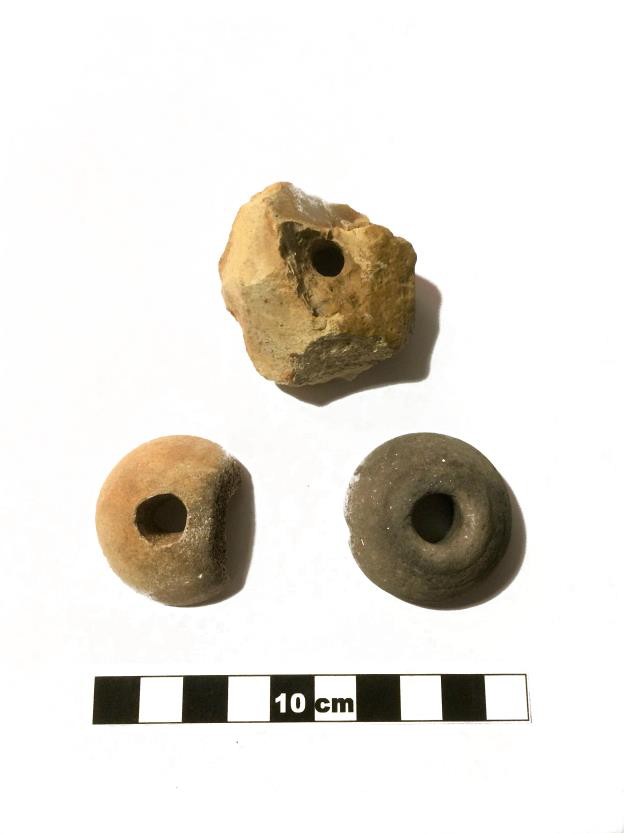
Spindle whorls (textile-production tools) recovered from one of the sunken-featured buildings
Four well-preserved sunken-featured buildings (SFB) were also discovered. This type of timber building was constructed with a raised floor set over a rectangular pit. The pit helped with insulation, prevented damp and could double as storage space. The buildings would have had a wooden floor and walls along with a thatched roof. The postholes at the base of the pit are generally the only trace left of the superstructure. These buildings were smaller than the timber-post buildings with a footprint of around 4m by 3m. Although the function of sunken-featured buildings probably varied from settlement to settlement, here they were likely utilised as workshops, with several textile-processing tools recovered from the largest one.
Three ovens were identified in and around the settlement. They comprised a cooking chamber, probably covered by a wattle and daub structure, that was heated by burning wood at the entrance, which was fed from an adjacent pit (known as a stoke-hole). Although there is little surviving evidence with which to confirm their function, it is likely that the ovens were used for baking food, such as bread, or drying grains to improve their storage lifespan and aid with processing. One of the ovens featured a stone lining at the base of the chamber, which probably helped to retain heat and cook the contents. The ovens were positioned away from any buildings, presumably to prevent the risk of fire spreading.
WHAT HAPPENS NEXT
The archaeological investigation within the development site is now complete. The Bedford Borough Council Archaeology Team confirmed that it was done to a satisfactory standard and the site has been handed back to Dandara so that construction can commence. Ultimately an archaeological report will be produced describing the results of the fieldwork. With the landowner’s permission, the finds will be deposited with The Higgins Art Gallery & Museum, Bedford.
Summary by Iain Leslie and Matteo Palombelli